A massive magnitude 7.8 offshore earthquake struck the southern Philippines early Monday, killing at least four people and injuring over 200 others across the Mindanao region. The violent shaking triggered widespread structural collapse in General Santos City and generated a one-meter tsunami that washed onto adjacent shores, forcing immediate mass evacuations.
The disaster struck at 7:37 AM local time, catching communities during morning commutes and school assemblies. The epicentre was located just 13 kilometres southwest of General Santos, a major economic hub with a population exceeding 700,000. Data from the Philippine Institute of Volcanology and Seismology (PHIVOLCS) traced the rupture to the Cotabato Trench at a depth of 10 kilometres, while the United States Geological Survey recorded it at 55 kilometres. Despite differing depth assessments, the energy released shook the entire southern peninsula, making it the most powerful seismic event to strike the archipelago this year.
Anatomy of the Cotabato Trench Rupture
The southern Philippines sits atop a volatile junction of converging tectonic plates. This specific disaster was born in the deep recesses of the Cotabato Trench, an oceanic depression where the Celebes Sea basin subducts beneath the Philippine Mobile Belt.
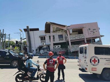
When tectonic plates lock, stress builds until the rock fractures. The sudden release of energy on Monday sent shockwaves through the regional capital, warping concrete and shearing support columns. In General Santos, a critical access bridge developed deep, dangerous fissures, effectively severing a vital transit artery. The upper floor of a prominent Jollibee fast-food restaurant completely pancaked, while the outer concrete facades of a nearby commercial complex cascaded onto the streets below.
Three of the confirmed fatalities occurred within General Santos, where falling debris crushed vehicles and compromised small commercial buildings. The fourth victim was reported in Davao Oriental province, a casualty of a collapsing concrete perimeter wall.
The Race Against the Tide
Minutes after the ground stopped swaying, the sea began its retreat, a classic precursor to a tsunami.
PHIVOLCS immediately issued a severe coastal warning. President Ferdinand Marcos Jr. took to public broadcast systems to urge citizens in vulnerable coastal zones to flee immediately.
"Please heed the tsunami warning. Move to higher ground now. Do not wait," Marcos warned. "Your life is more important than anything left behind."
The Pacific Tsunami Warning Center initially flagged potential waves of up to three meters for the Philippines. Land-based monitoring stations soon recorded wave surges reaching one meter along the coasts of Sarangani and Sultan Kudarat.
The threat was not localized to the Philippine archipelago. The displacement of the seabed pushed water outward across the western Pacific Ocean. Neighboring Malaysia issued a tsunami advisory for its eastern Sabah state on Borneo island, just a short boat ride from Mindanao. Indonesia registered an 83-centimeter wave gauge alteration off Sulawesi island, prompting local maritime alerts. Smaller, non-destructive sea-level variations were logged as far away as Japan and Papua New Guinea, highlighting the trans-oceanic reach of a magnitude 7.8 thrust event.
Panic in the Classrooms
Because the earthquake occurred during the opening hour of the standard work and school week, thousands of citizens were gathered in public spaces. In Davao del Sur, students were lined up for traditional Monday morning flag-raising ceremonies when the earth rolled.
Portions of a high school structure gave way as children scrambled for open ground. Ednar Dayanghirang, a regional director for the Office of Civil Defense, confirmed that more than 100 students sustained cuts and bruises during the ensuing stampede. Dozens of others fainted from hyperventilation and sheer panic.
Emergency response teams faced immediate gridlock. Power grids failed across multiple provinces, knocking out traffic signals and disrupting digital communication networks. Ambulances struggled to navigate streets littered with fallen electrical poles and shattered masonry. In General Santos, the local branch office of the DZRH radio station partially collapsed, forcing broadcasters to abandon their equipment and run for survival.
The Looming Threat of Aftershocks
The initial rupture was only the beginning of Mindanao's ordeal. Within hours of the main shock, a relentless sequence of aftershocks began rattling the already weakened infrastructure.
Seismologists recorded dozens of secondary tremors, including several exceeding magnitude 6.0, with the largest peaking at 6.5. These secondary events present a severe risk to rescue workers attempting to clear rubble from unstable buildings. The Office of Civil Defense issued strict directives forbidding residents from entering cracked or leaning homes until structural engineers can verify their integrity.
This region is no stranger to tectonic violence. Mindanao has endured multiple major earthquakes over the past three years, including a devastating magnitude 7.6 event in December 2023. This repetitive stress prevents the ground from fully settling and leaves older, unreinforced concrete buildings highly susceptible to progressive failure.
Local disaster management teams have set up temporary triage centers in public parks and gymnasiums. Medical personnel are treating hundreds of citizens for lacerations, fractures, and acute psychological trauma. As night falls across the southern islands, thousands of displaced families face the prospect of sleeping in open fields, terrified that the next aftershock might bring down what remains of their homes.