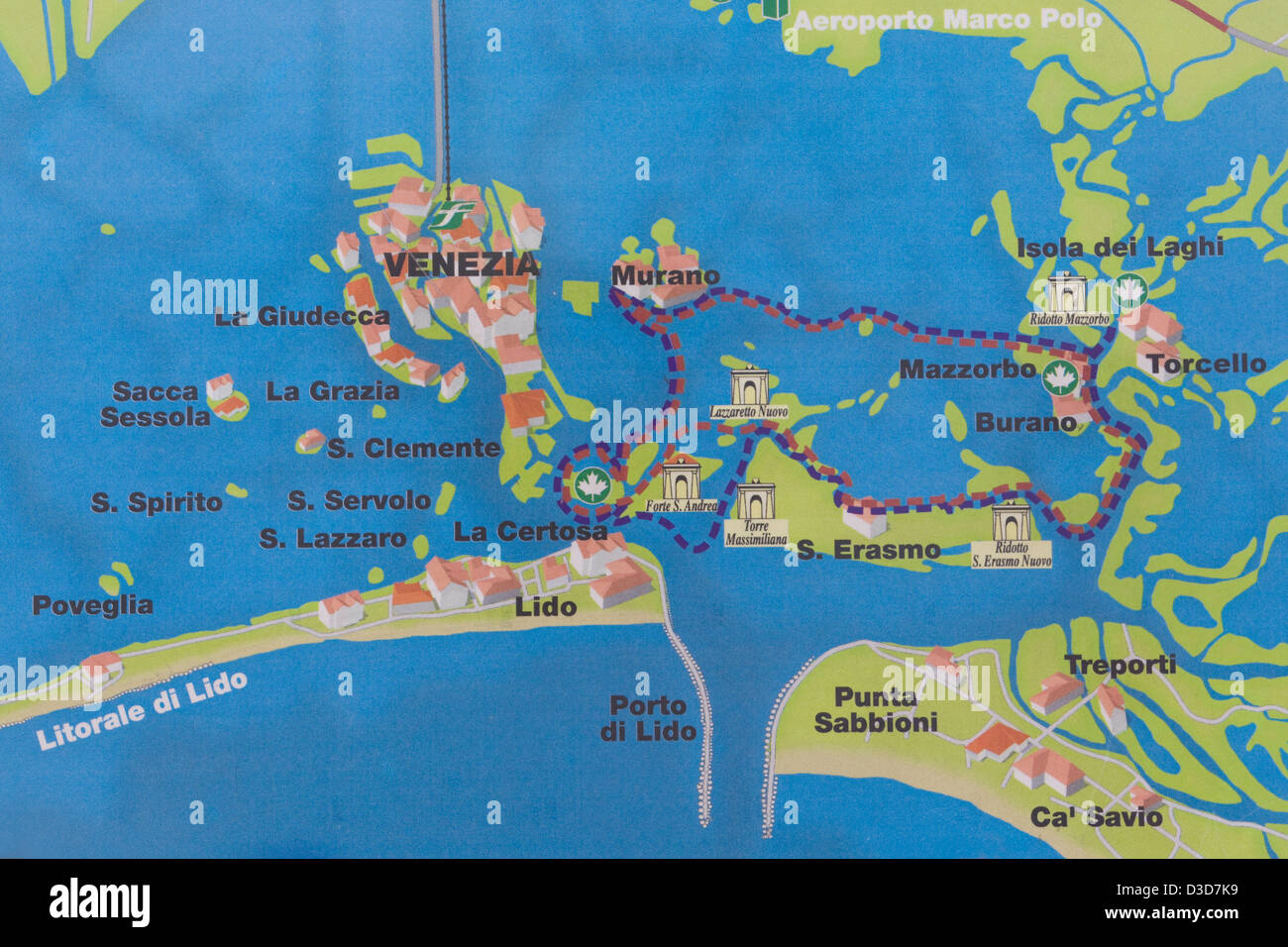
Venice isn't a city. Well, it is, but not in the way most people think when they’re looking at a standard atlas. It’s a literal jigsaw puzzle of mud, wooden piles, and history floating in a lagoon. If you look at a map of Venice Italy islands, you aren't just looking at one landmass with some canals cut through it; you're looking at over 100 tiny islands linked by roughly 400 bridges. It’s chaotic.
Honestly, the first time you see the "fish" shape of the main city from above, it looks manageable. It isn't. You'll get lost. That's a guarantee. But the real mistake people make is staying stuck in the "fish" and forgetting the rest of the archipelago. For another look, check out: this related article.
Understanding the Map of Venice Italy Islands and Why It's Basically a Maze
Let's get the geography straight because the scale is deceptive. The Venetian Lagoon covers about 550 square kilometers. Most of that is water or salt marshes, but the bits people care about are scattered like breadcrumbs.
The main center, the one with St. Mark’s Square and the Rialto, is actually two large islands separated by the Grand Canal. But when you pull back on a map of Venice Italy islands, you start seeing the outliers. You’ve got the Lido protecting the lagoon from the Adriatic Sea. You’ve got the northern islands like Murano and Burano. Then there’s the spooky stuff, like Poveglia, which is technically off-limits because of its history as a plague quarantine station. Similar coverage regarding this has been shared by National Geographic Travel.
The water depth in the lagoon is surprisingly shallow—on average, it’s only about one or two meters deep outside the main shipping channels. This is why the Vaporetto (the water bus) follows very specific routes marked by briccole, those thick wooden poles tied together. If the captain veers off the path shown on your map, the boat is going to get stuck in the mud.
The "Big Three" Beyond the Center
Most people manage to find Murano. It's the closest "major" stop. If you're looking at your map, it’s just north of the city. Murano is actually a cluster of seven islands joined by bridges. It's famous for glass, obviously, but the real pro tip is visiting the Basilica di Santa Maria e San Donato. It has a mosaic floor from the 12th century that rivals San Marco, and supposedly, it houses the bones of a dragon slain by Saint Donatus.
Then there’s Burano. It’s further out. You’ll need about 45 minutes on the Line 12 Vaporetto from Fondamente Nove to get there. It’s the one with the neon-colored houses. Legend says fishermen painted them bright colors so they could find their way home through the thick lagoon fog. It sounds like a marketing myth, but when the nebbia rolls in during November, you’ll believe it.
Right next to Burano is Torcello. Do not skip this. On a map of Venice Italy islands, it looks like a tiny, green speck. It’s nearly empty now—maybe a dozen people live there full-time—but it was once more powerful than Venice itself. The Cathedral of Santa Maria Assunta holds some of the most intense Byzantine mosaics in Europe. Standing there feels like being at the edge of the world.
The Lido and the Outer Rim
The Lido is a different beast entirely. It’s long, skinny, and—wait for it—has cars. If you’re looking at a map of Venice Italy islands and see a straight line on the eastern edge, that’s it. It acts as a barrier. It’s where the Venice Film Festival happens. It feels less like a medieval fever dream and more like a faded 1920s beach resort.
South of the main city is Giudecca. It’s that long strip of land you see across the water from St. Mark’s. It used to be a place for palaces and gardens, then it became industrial, and now it’s arguably the coolest part of Venice. It has the Redentore Church, designed by Palladio, which is a masterpiece of Renaissance symmetry.
- San Giorgio Maggiore: The island with the tower directly across from the Doge's Palace. Go here for the best view of the city.
- San Michele: The cemetery island. It’s where Igor Stravinsky is buried. It's serene, walled-off, and slightly eerie.
- San Lazzaro degli Armeni: A tiny island that's been an Armenian monastery since 1717. Lord Byron used to swim there to study Armenian.
The Logistics of Getting Around Without Losing Your Mind
You can't walk between these islands. I mean, you can walk within the main city, but to get to Murano or the Lido, you need the ACTV water buses.
The apps are hit or miss. CheBateau is usually decent for schedules. Google Maps is "okay," but it often struggles with the tight "calli" (streets) and the exact pier locations. Always look for the yellow signs at the Vaporetto docks.
One thing the maps don't tell you is the Acqua Alta (high water). When the tide rises, certain parts of the map basically disappear under six inches of water. St. Mark’s Square is the lowest point in the city, so it floods first. If you see the locals putting up those elevated wooden walkways called passerelle, follow them.
Why the Map Changes Every Few Decades
Venice is sinking. Or the sea is rising. It’s a bit of both. The MOSE project—the giant yellow gates at the lagoon openings—is designed to stop the city from drowning, but the geography is still fragile.
There are "ghost islands" on older maps of the Venice lagoon. Islands like Ammiana and Costanziaco were once thriving communities that eventually succumbed to erosion and malaria. They’re gone now, swallowed by the silt. When you look at a modern map of Venice Italy islands, you’re looking at a snapshot of a battle against the tide.
Actionable Strategy for Your Visit
Don't try to see it all in two days. It won't happen.
First, get a 24-hour or 48-hour Vaporetto pass. Buying single tickets is a scam; they’re roughly 9.50 Euro a pop now. A pass pays for itself by your third ride.
Start your morning at Fondamente Nove. Take the Line 12 boat. Hit Torcello first while it's quiet. Then walk back through Burano for lunch (get the risotto at Trattoria da Romano if you can get a table). Finish your afternoon in Murano before heading back to the main city as the sun sets.
If you want to escape the crowds entirely, look at the southern lagoon. Take a boat to Pellestrina. It’s a long, thin island south of the Lido where tourists rarely go. It’s just sea walls, small colorful houses, and very fresh fish. It’s the Venice that existed before the cruise ships arrived.
Finally, remember that the "Sestieri" are the six districts of the main island: Cannaregio, Castello, Dorsoduro, San Marco, San Polo, and Santa Croce. Knowing which one you’re in helps when the GPS fails, which it will. Look at the wall signs—the nizioletti. They are hand-painted and point you toward "Per Rialto" or "Per S. Marco." Trust the walls more than your phone.