Tropical cyclones do not form by accident, and climate change is fundamentally altering their internal engines. At its core, a hurricane or typhoon requires a precise cocktail of warm ocean water, high atmospheric humidity, and low wind shear to spin into existence. As global temperatures rise, the baseline physics of our atmosphere change, pumping unprecedented amounts of thermal energy into the ocean. The result is not necessarily a higher frequency of storms, but a measurable shift toward hyper-destructive, rapidly intensifying monsters.
To understand where the threat lies, we have to look past the sensationalized weather maps and examine the raw mechanics of the planet's atmospheric heat engines.
The Thermal Engine Under the Hood
A tropical cyclone is, stripped of its meteorological mystique, a massive thermodynamic engine. It takes heat from the warm surface of the ocean and converts it into kinetic energy in the form of wind and rain.
The process begins when ocean surface temperatures reach at least 26.5°C (79.7°F). This warm water evaporates rapidly, creating a thick layer of warm, moist air directly above the sea. As this air rises, it creates a low-pressure zone beneath it. Surrounding air rushes in to fill the void, absorbs heat and moisture from the ocean, and rises in turn.
地球 (Earth's) rotation provides the necessary spin through the Coriolis effect. Without this rotational force, the rushing air would simply move straight toward the center of the low-pressure zone and equalize it. Instead, the air curves, creating the characteristic spiral pattern of a tropical storm. As the rising moist air cools in the upper atmosphere, it condenses into clouds and releases latent heat. This latent heat warms the surrounding air, causing it to rise even faster, drawing more moisture from the sea, and driving the pressure at the center of the storm lower and lower.
If this system encounters strong vertical wind shear—meaning wind speed or direction changes drastically with altitude—the top of the storm gets sliced off, disrupting the engine. When wind shear is weak, the storm organizes, stabilizes, and grows.
Why the Location Changes the Name
The difference between a hurricane, a typhoon, and a cyclone is entirely geographical. They are the exact same meteorological phenomenon.
- Hurricanes develop over the North Atlantic Ocean, the Northeast Pacific, and the South Pacific east of 160°E.
- Typhoons form in the Northwest Pacific Ocean, threatening East Asia.
- Severe Tropical Cyclones or Severe Cyclonic Storms occur in the Indian Ocean and the Southwest Pacific.
A storm hitting the coast of Florida follows the identical physics of a storm slamming into the coast of Taiwan. The naming conventions are historical artifacts, not scientific distinctions.
The Misunderstood Link to Climate Change
A common misconception dominates public discourse. People see a brutal hurricane season and assume climate change is causing more storms to form. The data does not support this.
Historical baselines indicate that the global frequency of tropical cyclones has remained relatively steady at roughly 80 to 90 storms per year. Some models even suggest that the total number of storms may slightly decrease in the future due to shifts in global atmospheric circulation and increases in wind shear in certain regions.
The real crisis is intensity. We are seeing a distinct trend toward stronger storms.
$$\text{Power Dissipation Index} \propto \int_{0}^{\tau} V_{\max}^3 , dt$$
The thermodynamic upper limit of a storm's strength—known as its maximum potential intensity—is dictated by the temperature difference between the ocean surface and the upper atmosphere. Because the oceans have absorbed over 90% of the excess heat generated by greenhouse gas emissions, that temperature differential is widening. We are fueling these engines with higher-octane fuel.
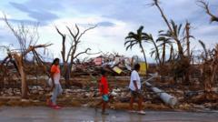
The Real Threats Nobody Is Talking About
Focusing exclusively on wind speed misses the most dangerous transformations occurring in modern storms. Three distinct factors are escalating the human and economic toll of these weather events.
Rapid Intensification is Becoming the Norm
Meteorologists define rapid intensification as an increase in a storm’s maximum sustained winds of at least 35 knots (about 40 mph) within a 24-hour window. This used to be a rare anomaly. Now, it happens regularly, frequently right before landfall.
When a storm moves over deep pools of exceptionally warm water, its internal engine goes into overdrive. Coastal communities go to sleep preparing for a manageable Category 1 storm and wake up to a catastrophic Category 4 monster. This compresses evacuation timelines to zero, leaving emergency management systems paralyzed.
Atmospheric Water Storage Has Exploded
Basic physics dictates that warm air holds more moisture than cold air. Specifically, the Clausius-Clapeyron relation demonstrates that the water-holding capacity of the atmosphere increases by about 7% for every 1°C of warming.
$$\frac{d e_s}{dT} = \frac{L , e_s}{R_v , T^2}$$
This translates directly into unprecedented rainfall totals. Storms are no longer just wind events; they are inland deluge events. The flooding observed in recent years from storms lingering over land is a direct consequence of an atmosphere saturated with evaporated ocean water.
The Deceleration of Storm Movement
Storms are moving across the landscape at a slower pace. The forward translational speed of tropical cyclones has decreased globally over the past several decades.
This slowing is linked to a weakening of the steering currents—the large-scale atmospheric winds that push storms along their paths. When a storm stalls over a region, the impacts multiply exponentially. Instead of receiving a brief battering of wind and rain over six hours, cities are subjected to relentless pounding and continuous rainfall for days on end, overwhelming infrastructure designed for a different era.
The Friction of Uncertainty
Science operates on data, not dogma. While the link between ocean warming and storm intensity is backed by solid physics, detecting clear historical trends remains difficult due to poor data quality from the pre-satellite era.
Before the late 1970s, scientists lacked global satellite coverage to accurately measure storm intensity in the middle of the ocean. Comparing a modern storm tracked via high-resolution satellite imagery and hurricane-hunting aircraft with a storm from 1920 relies on historical estimates and ship logs. This observational gap creates a gray area that climate skeptics exploit, but the modern physics remain unassailable. The ocean surface is warmer, sea levels are higher, and the thermodynamic potential for extreme events is undeniably elevated.
The Concrete Action Plan for Coasts
Accepting this reality means abandoning outdated building codes and zoning laws based on 20th-century statistics. Sea level rise guarantees that modern storm surges push further inland than they did fifty years ago, rendering existing flood maps obsolete.
Cities must invest heavily in hard infrastructure like storm surge barriers while simultaneously restoring natural defenses like coastal mangroves and wetlands, which act as physical shock absorbers for incoming waves. Governments must enforce strict, wind-resistant construction standards and implement managed retreat strategies for areas that can no longer be defended. Waiting for definitive 100-year trends to materialize before upgrading infrastructure is a strategy for bankruptcy.