The deployment of a semi-submersible, modular floating platform at Scarborough Shoal represents a calculated shift from tactical harassment to structural permanence within the West Philippine Sea. While mainstream media reporting frames the appearance of this object as an isolated incident or a vague "mystery," a systematic analysis of the mechanics of Chinese maritime power projection reveals a highly coordinated blueprint. This strategy uses the legal and operational cover of Marine Scientific Research (MSR) to achieve long-term, irreversible territorial revisionism without triggering an armed conflict under the United States-Philippines Mutual Defense Treaty.
To neutralize or counter this operational model, one must first dismantle the technical, legal, and structural variables that govern it. The deployment of physical infrastructure inside the lagoon of a contested atoll is not a random assertion of sovereignty; it is a precisely timed execution of a gray-zone doctrine designed to exploit gaps in international law and regional enforcement capabilities.
The Dual-Use Infrastructure Framework
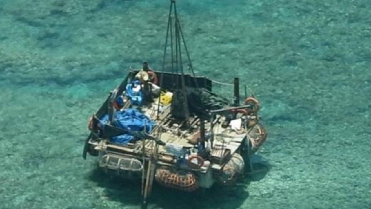
The platform discovered inside Scarborough Shoal—estimated at approximately 30 square meters of deck area and equipped with four mechanical vertical stilts—is structurally engineered for rapid deployment and positional stabilization. It is not an artificial island, nor is it a standard naval asset. It functions as a modular, dual-use node designed to optimize two distinct variables: operational deniability and acoustic-bathymetric data acquisition.
The physical attributes of the platform dictate its functional capabilities:
- Variable Geometry and Mobility: The inclusion of four metal stilts allows the platform to alternate between a floating state and a fixed-point shallow-water installation. This mechanical configuration enables Chinese personnel to alter the legal classification of the structure depending on the proximity of Philippine patrols, shifting from a "vessel" to a "fixed installation."
- Hydrological and Acoustic Data Gathering: The deployment coincides with the prolonged presence of two specialized Chinese research vessels: the Yue Xia Yu Zhi 20028 and the Yue Zhan Yu 6. The pairing of these vessels with a stationary platform indicates a systematic effort to map the underwater topography, salinity profiles, and thermal layers of the northern South China Sea.
- Subsurface Communication Network Nodes: In modern naval warfare, high-resolution bathymetric data is the fundamental input for submarine warfare. The deep waters surrounding Scarborough Shoal form a critical transit corridor. Mapping these waters provides the People's Liberation Army Navy (PLAN) with the data required to optimize acoustic models for submarine detection and stealth transit.
The primary mechanism here is the deliberate blurring of civilian research and military intelligence. Under Article 246 of the United Nations Convention on the Law of the Sea (UNCLOS), coastal states possess the right to regulate MSR within their Exclusive Economic Zone (EEZ). By defining the platform’s operations strictly as "scientific research," Beijing constructs a legal shield. This shield forces the Philippines and its allies to choose between tolerating the data collection or initiating a physical intervention against an explicitly non-military target.
The Escalation Ladder and Salami-Slicing Logistics
The chronological deployment of the structure between late May and June 2026 demonstrates an operational sequence designed to test the reaction thresholds of the Armed Forces of the Philippines (AFP) and the United States military. The operation followed a precise three-phase sequence.
[Phase 1: Verification] -> [Phase 2: Deployment] -> [Phase 3: Internalization]
  No structure on May 20     Platform at mouth May 25     Moved into lagoon May 31
  Research ships arrive      6 personnel on deck         15 personnel + support boats
This sequence reveals that China's maritime strategy operates on a highly responsive feedback loop. The initial placement at the southeastern entrance of the shoal functioned as a kinetic probe. When the initial deployment did not trigger an immediate, physical counter-escalation by Philippine Coast Guard (PCG) assets—which were occupied tracking a wider armada of 82 Chinese hulls in the EEZ—the decision was made to move the platform inside the protected lagoon.
The structural logic of this "salami-slicing" methodology relies on minimizing the risk profile of each individual action. Installing an artificial island via massive dredging ships, as seen in the Spratly Islands a decade ago, carries an extreme diplomatic and strategic cost. In contrast, towing a 30-square-meter modular platform using civilian-flagged research boats represents a low-capital, high-flexibility investment that achieves similar long-term monitoring objectives.
Legal and Geopolitical Asymmetry
The fundamental bottleneck in the Philippines' counter-strategy is the asymmetrical enforcement landscape governing Scarborough Shoal. The 2016 Permanent Court of Arbitration ruling explicitly invalidated China’s expansive historical claims and affirmed that Scarborough Shoal is a traditional fishing ground located within the Philippine EEZ. However, the international architecture lacks a centralized enforcement mechanism to execute arbitral awards.
China capitalizes on this institutional void through a calculated resource-attrition model:
- The Coast Guard Supremacy Function: By maintaining a permanent vanguard of hulls around the shoal, China imposes an economic and operational tax on the PCG. The cost for Manila to sustain a continuous naval or coast guard presence 240 kilometers west of Luzon exceeds the cost for Beijing to maintain a forward-deployed, rotating fleet supplied by major bases in Hainan and the Paracel Islands.
- The Deterrence Gap: The United States-Philippines Mutual Defense Treaty covers armed attacks on Philippine public vessels, aircraft, and armed forces in the South China Sea. A non-military floating platform, manned by individuals in civilian attire and designated as a scientific outpost, sits entirely below the threshold of an "armed attack."
- The Administrative Annexation Blueprint: In late 2025, Beijing declared Scarborough Shoal to be a state-protected nature reserve. The introduction of the scientific platform in mid-2026 is the direct logistical execution of that administrative declaration. By enforcing domestic environmental and scientific regulations on a feature inside another nation's EEZ, China builds a historical record of continuous administrative control.
This creates a severe structural dilemma for Manila. If the Philippines ignores the platform, China establishes a permanent, monitored foothold inside the lagoon. If the Philippines attempts to physically seize or tow the platform away, China can frame the action as an aggressive escalation against a peaceful scientific research project, providing the necessary justification for a large-scale intervention by the nearby PLAN fleet.
Operational Constraints of the Gray-Zone Architecture
While China’s strategy appears highly effective, it contains deep structural vulnerabilities that limit its scalability. Recognizing these limitations is essential for developing an actionable counter-strategy.
The first major limitation is environmental and structural fragility. Unlike the reinforced concrete fortresses of Mischief Reef or Subi Reef, a floating modular platform is highly vulnerable to the extreme weather conditions characteristic of the South China Sea. During typhoon seasons, a platform lacking heavy mooring infrastructure must either be evacuated and towed back to Hainan or risk total destruction. This creates a seasonal gap in operations that disrupts continuous data gathering and structural presence.
The second vulnerability lies in information transparency. The deployment was exposed almost instantly through high-resolution commercial satellite analytics and maritime intelligence watchdogs. This transparency strips away the advantage of tactical surprise. When the presence of these structures is documented in real-time, it allows the international community to consolidate diplomatic opposition before the infrastructure can be converted into a militarized asset.
The Strategic Counter-Play
To counter the normalization of Chinese research infrastructure within its maritime domain, the Philippines cannot rely on traditional diplomatic protests alone. Manila must execute an asymmetric strategy that shifts the cost-benefit calculus back against Beijing.
The optimal strategic response requires the execution of three simultaneous operations:
- Reciprocal Scientific Declassification: The Philippines must immediately deploy its own Bureau of Fisheries and Aquatic Resources (BFAR) vessels, alongside university marine biologists, to conduct public, highly visible scientific research directly alongside the Chinese platform. If Beijing claims the area is an open research zone, it cannot legally block Philippine scientists without invalidating its own foundational argument.
- The Integration of Autonomous Maritime Domain Awareness: To offset the high financial cost of maintaining crewed hull presence, the AFP must deploy long-endurance, low-cost autonomous surface vessels and underwater gliders around Scarborough Shoal. These assets can continuously record the acoustic signals, telemetry, and activities of the Chinese platform, neutralizing its intelligence-gathering advantage by broadcast-publishing the data to global maritime command centers.
- Multilateral Environmental Enforcement Interventions: Since China has framed its presence around environmental management and scientific research, the Philippines should form a joint coalition with regional partners—such as Japan, Australia, and Vietnam—to establish an international marine sanctuary protection task force. This elevates the dispute from a bilateral sovereignty clash to a multilateral enforcement of global maritime environmental law, raising the political cost of unilateral Chinese interference to an unsustainable level.


